Commercial and residential construction projects now rely heavily on high precision geospatial data. Property boundaries, grading plans, drainage design, and building placement all depend on survey information collected at the earliest stages of project planning.
Over the past two decades, land surveying has shifted from manual field measurements to digitally driven geospatial systems. Technologies such as RTK GNSS positioning enable surveyors to obtain centimeter level accuracy, while drone mapping has made large parcel surveys faster.
Here are 5 innovative technologies evolving land surveying to support land development in Ontario:
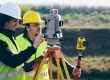
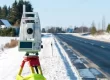
1. RTK GNSS Positioning Systems
Real Time Kinematic Global Navigation Satellite Systems (RTK GNSS) have become a fundamental tool in modern land surveying. This technology helps land surveyors determine geographic coordinates and elevation data with centimetre level accuracy by correcting satellite positioning signals in real time.
RTK systems largely replaced several traditional surveying approaches that were slower and required more manual setup:
Common applications include:
- Establish site control points for construction layout
- Map large development parcels and subdivision sites
- Provide elevation data required for grading and drainage design
- Boundary surveys and property line verification

2. Drone-Based Aerial Surveying
Survey drones equipped with high resolution cameras and photogrammetry software capture aerial imagery that can be processed into accurate orthomosaic maps and terrain models. Traditionally, surveyors would physically traverse large areas of a site, which could be time consuming and sometimes difficult in locations with limited access.
Common applications include:
- Aerial mapping of large commercial and industrial development sites
- High resolution aerial imagery for site planning and feasibility review
- Construction progress documentation during active development
3. 3D Laser Scanning
With 3D Laser Scanning, surveyor firms in Ontario are able to record millions of individual data points that form an accurate digital representation of physical spaces. This replaced the need for manual point collection, which limited the number of measurements recorded during field work.
Common applications include:
- Capture detailed spatial data for existing commercial or industrial buildings
- Produce accurate as built documentation for renovation or redevelopment products
- Record structural geometry for engineering analysis
4. Building Information Modelling (BIM) Integration
Building Information Modelling provides a structured digital framework through which architectural, engineering, and construction information can be coordinated within a single project environment.
Common applications include:
- Provide geospatial reference data for integrated project models
- Support coordination between architectural, structural, and civil design disciplines
- Verify building placement relative to site boundaries and elevation benchmarks
- Assist design teams with site layout planning within coordinated digital models
5. Digital Terrain Modelling (DTM)
Digital Terrain Modelling converts topographic survey measurements into detailed digital representations of land surfaces. These models illustrate elevation changes, slopes, and site features across a property. Engineers and planners use these models to analyze terrain conditions before construction begins.
Traditionally, surveys relied on fewer elevation points collected through manual measurements across a site.
Common applications include:
- Provide terrain models that illustrate elevation changes across development sites
- Support grading design and drainage analysis for commercial projects
- Supply terrain data required for site servicing and road layout planning
- Document existing ground conditions before excavation or construction begins
Land Surveyor in Kingston and Sudbury
Avant Garde Geomatics is led by Juzer Noman, a licensed Ontario Land Surveyor with advanced training in geomatics. Juzer approaches surveying with a clear focus on accuracy, data quality, and modern geospatial methods.
Clients benefit from leadership that understands both the science behind surveying and the practical experience in the commercial space. We incorporate technologies such as RTK GNSS positioning, drone based aerial surveying, 3D laser scanning, digital terrain modelling, and BIM compatible data workflows to support accurate site analysis and project planning.
Reach out today to schedule a free consultation and start your project with confidence.